
US Highway 75 aka the Postal Highway aka King of Trails aka the Gulf Highway
- Robin Cole-Jett
- May 20, 2025
- 10 min read
Updated: May 27, 2025

If you live in Dallas, US 75 is known as Central Express Way and it's a bear. The traffic on this road, dug like a canyon (but not nearly as scenic) on the eastern side of downtown, makes a driver wish they were someplace else. That's actually a possibility, come to think of it, because US 75 was once an amalgam of named highways known by different names that can still be driven on its original routes from Kansas to Galveston, Texas, most notably the King of Trails, Postal Highway, and the Gulf Highway.
The "King of Trails" is honestly a weird name to give a highway. It was bestowed on the route in the time when automobile tourism was promoted between cities along privately-maintained roads that were once wagon routes. However, since the road's purpose was to link the mid-west to the Gulf of Mexico, its route is also referred to as the "Kansas-Oklahoma-Texas-Gulf Highway," or the "Gulf Highway" for short. The directions and improvements (meaning, the path was paved, not dirt) differed depending on where merchants and town promoters wanted to steer travelers to. But whatever its name, original alignments are definitely worth thorough investigations. Much of the infrastructure surrounding these routes has been preserved, if bypassed for the more modern, speedier highway. You just have to know how and where to look for it! Luckily, you landed on this page so I can clue you in.
The King of Trails (US 75, kind of) took travelers from Minnesota to Texas. At Muskogee, Oklahoma, it is is also a portion of the Jefferson Highway that is known today as US 69. US 75 doesn't go to Muskogee; today, US 75 travels to Tulsa. For our purposes, the journey will retrace US 75 south of the Canadian River.
Of course we're going to concentrate on the Red River Valley's portion of the King of Trails aka Gulf Highway aka US Highway 75. But geography will be fast and loose to make sure you don't miss any of the not-directly-at-the-Red-River scenes!

Oklahoma: From Calvin to Durant via Tishomingo over the Postal Highway / Gulf Highway
We're going to start the journey along the original US 75/Gulf Highway -- it won't be the King of Trails until McAlester --- at the northern boundary of the Choctaw Nation: the Canadian River at Calvin, Hughes County.
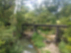
Today, Calvin is a small town at the foothills of the Shawnee Mountains on the north side of the Canadian River. But that doesn't mean it's insignificant. Calvin has FOUR bridges that span the river: the arched CRIP (Chicago Rock Island and Pacific Railroad) to the west; the boring, concreted modern US 75; the beautiful old truss bridge for the original Postal Highway that is now a walkway, dedicated in 1921; and the square steel of the MOG/KOG (Missouri Oklahoma Gulf that became the French-owned Kansas Oklahoma Gulf Railway) on Calvin's eastern side.
At Calvin, US 75 was the "Postal Highway" that veered west towards Oklahoma City or east towards McAlester. It was imagined in 1912 as the "greatest East and West interstate road south of the Santa Fe Trail" (according to its president, J.A. Whitehurst) that linked Little Rock to California. It crossed the North Fork of the Red River at Sayre, Oklahoma -- today, that's the old crossing for Route 66.
To see the original US 75/Postal Highway at Calvin, cross the Canadian River along the modern US 75 and then, turn left (west) onto either the first or second streets past the bridge. Suddenly, you're on the highway's original pavement! Follow this beautiful road to the highway's original truss bridge. You can't drive it anymore, but you can walk it. The surface of the bridge reveals layers of road building, including wooden block.
Today, US 75 is easy to follow south of Calvin, and it is extremely scenic. But in the 1910s, it was an unimproved road as the towns it went to (Coalgate and Lehigh) were coal mining communities that weren't meant for tourists. So, if you want to follow the original tourist routes, you'll take US 75/Postal Highway north to Horntown, then west to Holdenville, then west on Hwy 270 to Tecumseh, then south on US 177 from Tecumseh to Sulphur. Interestingly, US 177 was once known as the Ozark Trail, part of which would later become the famous Route 66.
South of Sulphur on US 177, turn eastward on Cyris Harris/Old MIll Creek Road -- this is the part of Oklahoma's "Bankhead Highway." From Mill Creek, go south on OK 1, then east on OK 7 past Reagan, then turn southward onto Log Cabin Road, where an old log cabin once was the area's main grocery store. Log Cabin Road will take you to US 377, which you then follow southward into Tishomingo.
At Tishomingo, take OK 78 southeast to Durant. Now, you're on the Gulf Highway that leads to US 75 again!


Oklahoma: From Calvin to Durant via McAlester over the Jefferson Highway/ King of Trails
At Calvin, you can also go eastward on US 270 - formerly the "Postal Road" to McAlester. US 270 becomes the "Carl Albert Parkway." Once you go over the railroad tracks, turn south on Main Street -- this is US 69, aka the Jefferson Highway. South of McAlester, you will have a choice to make: you can stay on the new, four-lane US 69 or follow the Old Highway 69. Guess where we're going? You'll take Old Highway 69 at Chambers turn off (west). When you turn onto Chambers Road, you'll immediately turn left onto Old Highway 69 -- in other words, you'll follow the railroad tracks southward, not cross them.
Old Highway 69/ Jefferson Highway will pass through Savannah. Thereafter, you'll have to drive on the new US 69 until just north of Kiowa, where you'll turn onto North Harrison Street -- the former Jefferson Highway/Old Highway 69, parallel to the railroad tracks. Those tracks, now used by the Union Pacific Railroad, comprise the first ROW in Oklahoma's history: they were originally built the Missouri, Kansas, and Texas Railway, aka the KATY or MKT.
Keep on Old Highway 69 past the power plant, but then return to the new US 69 to travel past Limestone Gap. Unfortunately, you can't access the former towns of Gap and Chockie at Limestone Gap anymore; for some reason, the roads have been fenced off (public land theft is still ongoing in the Red River Valley, just FYI).
The new US 69 takes you through Stringtown, but I always caution people to be careful here -- traffic goes much too fast for this old road that has no breakdown lane and lots of turn-offs. You'll go southward to Atoka, where you'll meet the turn=off for US 75 that will take you to the ghost town of Lehigh (a former mining town), Coalgate, and Calvin!


Oklahoma: From Durant to Texas on the King of Trails, Gulf, and Jefferson Highways
Go south on the new US Highway 69 past Tushka. The first left (southeast) turn about a mile past the Boggy Depot turn-off is the Old Highway 69/75 and King of Trails/Jefferson Highway. Along this historic route, you'll pass beneath concrete bridges that carry the MKT tracks, over the beautiful truss bridges at Clear Boggy Creek, and go through Caddo, which sports a Jefferson Highway mural (but no nod to the King of Trails, yet). Locals have painted the poles in the highway's iconic blue/white colors to commemorate the historic highway.
At Armstrong, the King of Trails/Jefferson Highway crosses over the beautiful Blue River. Then, you'll enter Durant. Turn due south onto OK 78/First Avenue, which is where the Jefferson Highway and King of Trails now meet the Gulf Highway. Turn left (west) on Main Street and then left (south) on 9th Street. South of Durant, 9th Street veers onto the modern US 69/US 75.
South of Durant is Calera, a railroad town that has been truly devastated by the widening and modernizing of the current US 75/US 69. The original highway alignments are now the service road, so take it because you'll then turn westward onto Smiser Road. Drive on Smiser Road several miles to Leavenworth Trail, named after the Dodge-Leavenworth expedition that was launched in 1834 from Fort Gibson to the Wichita Mountains in southwestern Indian Territory to broker peace with the Comanches. Famed artist George Catlin was part of this group, which met with a fever outbreak that eventually killed 150 people, including General Henry Leavenworth, who died along this road in the Cross Timbers.
Leavenworth Trail aka the King of Trails/Jefferson/Gulf Highway will bring you Colbert, a historic ferry and stage coach port on the Red River. The original roadway led to a toll bridge that in 1875 was the first bridge to cross the Red River in Indian Territory. A flood washed it away (and killed a young boy in the process). The bridge was not rebuilt until increased automobile traffic necessitated the erection of a steel truss bridge in the 1920s. The route to the toll bridge is Leavenworth Trail/Franklin Street/River Road.
Unfortunately, the toll bridge was dynamited after the short but intense "Red River Bridge War." Although remnants of the toll bridge still stand in the Red River, it's no longer passable, and travelers must take the current US 75 highway bridge across the Red River. It stands just below the dam for Lake Texoma.


Texas: King of Trails and Gulf Highway
Once in Texas, exit US 75 to follow US 69 into Denison. This is also the King of Trails route, at least for a few early miles: turn onto Houston Street and then, turn left (west) onto Main Street in downtown Denison. US 69 aka the Jefferson Highway continues straight on Crawford/Travis/Texas streets.
The King of Trails and Gulf Highway will now take you into Dallas past Sherman, Howe, Van Alstyne, Anna, Melissa, McKinney, Allen, Plano, and Richardson. The roads get busier and busier as they enter a metropolitan area that hos grown to house over 7 million people. Luckily for us, though, all of the old routes are now city streets and Texas highways.
Texas: Denison to McKinney
In Denison, follow Main Street west to Armstrong Avenue. Turn left (south); Armstrong will become Woodlawn Avenue. Follow it to turn west onto Flowers Drive, then bend with the road southward onto Theresa Drive where you'll pass over Iron Ore Creek. Theresa Drive ends at Fallon Drive; turn left (west) and then left (south) onto Frisco Road and follow it to Broughton, turn right (west) on Brockett Street, then turn left (south) on Travis Street and drive through downtown Sherman.
Past Sherman, Travis Street merges onto US 75. This kind of, sort of mimics the King of Trails/ Gulf Highway. The older highway re-appears along TX 5 at Howe. At Howe, there is actually an even older alignment, however; take Duke Street to Old Highway 6 east of TX 5 (across the old Houston & Texas Central Railway tracks, now used by Dallas, Garland and Northeastern Railroad) to follow the original tourist road into Van Alstyne. At Van Alstyne, you'll eventually find yourself at TX 5 again, which passes through Anna and Melissa.
Once past Melissa, TX 5 enters McKinney and divides the town between the east and the west. The original King of Trails/ Gulf Highway is Tennessee Street, which veers from TX 5 just before the intersection with US 380. Tennessee Street leads into downtown McKinney and then re-joins TX 5. This is also TX 121; at the intersection, turn left (south) to follow TX 5 into Allen.


Texas: Allen to Dallas
Nothing looks like what it once did as you drive through the suburban landscapes of Allen, Plano, and Richardson. The King of Trails/Gulf Highway aka TX 5 becomes Greenville Avenue pretty much the entire way into Dallas (except in Plano, where it is K Avenue and then, Plano Road). Once past Renner Road (which anchors the former town of Renner), turn southward on Greenville Avenue.
Greenville Avenue aka King of Trails/Gulf Highway gets more "historic" the closer you get to Dallas. Bricked store fronts, built during the 1920s and 1930s, line the street, and every once in a while, and old schools, apartment buildings, and fire station houses appear. When you see the right-hand curve for Ross Avenue, follow through Old East Dallas into downtown Dallas. This whole area was once home to many stately mansions. Now, most of these fancy houses along the old highway are in the Swiss Avenue historic district.
Ross Avenue will take you past the Dallas Museum Art, the Belo Mansion (which held Clyde Barrow's funeral in 1934) and the impressive skyscraper built by I.M. Pei known as "Fountain Place." Ross Avenue ends at Houston Street next to the Holocaust Museum. Turn left, pass over the DART Rail tracks (once the Dallas and Wichita Railway), and find yourself in the infamous Dealey Plaza, home of the Texas School Book Depository, from where Lee Harvey Oswald killed President John F. Kennedy in 1963.
Today, taking Houston Street southward will bring you to Oak Cliff. Most people drive on Interstate 45 south of Dallas to go to Houston instead, but that's a brand-new road. The King of Trails/Gulf Highway crossed the Trinity River, traversed Oak Cliff, and ran as 8th Street/Bonnie View Road to Hutchins and Lancaster on its way to the Gulf of Mexico.
But now we're out of the Red River Valley and in the Trinity River Valley, so we'll stop here. Happy Motoring!!!


