Robin Cole-JettMay 15Just floating an idea... literallyAn aero-trolley at Turner Falls, Oklahoma. This may have been the general idea of the proposed ferry over the Red River. Oklahoma.net In...
Robin Cole-JettMay 15Success by trialThe Coincoin-Prudhomme house along the Cane River in Natchitoches Parish, Louisiana was documented by the Historic Buildings Survey in...
Robin Cole-JettMay 15Going the distanceThe published account of the 28th Congressional Session in 1843 included a number of maps and drawings. These visuals helped to...
Robin Cole-JettMay 15Cynthia Ann's long journeyCynthia Ann Parker's body is reburied at the Post Oak Mission's cemetery near Indiahoma in Comanche, Oklahoma in 1910. Her son, Quanah...
Robin Cole-JettJan 12Walled in DenisonA while back, a reader of Red River Historian invited me to come to his property to see a very old structure. I'm not going to give away...
Robin Cole-JettAug 2, 2021A remarkable manOne bright, sunny, and very hot day, I traversed the Texas portion of US 82 into Archer County from Wichita County, on my way to some...
Robin Cole-JettAug 2, 2021Crossing at Doan'sIf you counted yourself among the fashionable pioneer set, a MUST-DO was to cross into Indian Territory by way of the Doan's Store....
Robin Cole-JettAug 2, 2021Milling around EliasvilleOne of the easiest ways to spot a ghost town is to follow abandoned railroad lines. When the companies were building their right-of-ways...
Robin Cole-JettAug 2, 2021Original Choctaw TownEagletown (McCurtain County, Oklahoma) began its existence within a decade after the Louisiana Purchase. American settlers, seeking new...
Robin Cole-JettAug 2, 2021Ghostly WatersLike Sulphur 40 miles to the west, Bromide (Johnston County, Oklahoma) was a spa town at the turn of the 20th century. Nestled inside...
Robin Cole-JettJul 26, 2021Map for mathematiciansMap fro the 28th Congressional Session, 1848, of distances between federal outposts in the American Southwest (LOC). The published...
Robin Cole-JettJul 26, 2021Mansura mappingI have never seen Mansura, Avoyelles Parish, Louisiana, well-represented on any map prior to satellite data. But we can figure out why...
Robin Cole-JettJul 26, 2021Longitudinal confusionThe Red River Valley above Fulton/ Clarksville / Fort Towson was not fully mapped until after the Civil War. The first regional mapping...
Robin Cole-JettJul 11, 2021Kiowa CalendarThe Oklahoma Historical Society has an unbelievable amount of photographs that only occasionally see the light of day. Their photos,...
Robin Cole-JettJul 11, 2021Jefferson devolutionJefferson, the county seat of Marion County, Texas, became an inland port after the first federal Red River raft (massive log jam)...
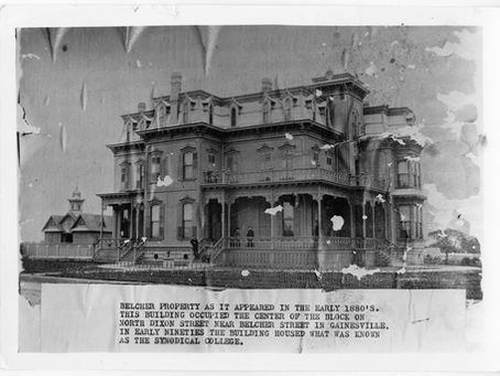
Robin Cole-JettJul 6, 2021Honeycutt FlatDue to work related activities, I've been nosing around Gainesville (Cooke County, Texas) lately. The city was founded as a settlement in...
Robin Cole-JettJul 6, 2021Whole 'nother countyTexas likes that it's big, and between 1860 and 1894, it was actually a million and a half acres larger than it is today. That's because...
Robin Cole-JettJul 6, 2021Great Spanish Road, Part IIVial's "Spanish Road" route begins in Natchitoches and passes by homes and ranches of traders/planters. It mentions several...
Robin Cole-JettJul 6, 2021Great Spanish Road, Part 1One of the least studied but apparently, major trade arteries emanating from the Red River was the so-called "Great Spanish Road" that...
Robin Cole-JettJul 6, 2021A Golden RoadThis map, published in Annaberg (Saxony), explained the relative location of Texas and the roads and trails that led to the California...