The Butterfield Overland Mail Route and Stagecoach
- Robin Cole-Jett
- Sep 1, 2023
- 6 min read

The Butterfield Overland Mail Route was the first transcontinental stagecoach in the United States and came right through the Red River Valley.
The first trans-continental transportation in the American Southwest was not a railroad but a stage coach, and it traveled right through the heart of the Red River Valley.
Thomas Jefferson once opined that the "United States was big enough" — meaning, he didn't see the need to extend beyond the Mississippi River or into Canada or even Spanish Texas, despite what congressional expansionists believed. Then, in 1803, a real estate deal with France fell into the country's collective lap. With one stroke of a quill,* the Louisiana Purchase doubled the size of the United States, and expansion fever went from dream to reality. In 1848, the United States' defeat of Mexico in the Mexican American War (1846-1848) brought the American myth of "manifest destiny" into fruition: the Mexican Cession extended the United States all the way to the Pacific Ocean. Time to start moving, right?
The problem with people moving from one coast to the other was many-fold. One, there were people who already occupied the lands, and they were none to keen to have pioneers establish homesteads on their hunting and trading territories. Two, the expeditions that the Louisiana Purchase solicited - like the Freeman & Custis, Lewis & Clark, and Zebulon Pike expeditions - had demonstrated that no rivers east of the Rocky Mountains extended past the Continental Divide to the Pacific Ocean, a fact that Randolph B. Marcy's exploration of the Red and Canadian rivers in 1852 steadfastly confirmed. Three, railroading was still in its infancy. Building tracks and purchasing locomotives proved very expensive, and most investors lost rather than gained money. This mode of transport would be the solution in the future, but that future was still decades away.
Jefferson Davis, who served as the Secretary of War under President Franklin Pierce from 1853-1857, ordered a number of surveys to be done for possible transcontinental railroad routes. Not surprisingly, the man who would become the President of the Confederacy (1862-1865) wanted the route to traverse slave states and potential slave states (New Mexico Territory), not free states. To that effect, in 1854 Ambassador James A. Gasdsen agreed upon purchasing additional land from Mexico in preparation for the southern route. Again not unsurprisingly, when the Pacific Railway Act was signed in 1862, the U.S. Congress ensured that the first transcontinental route only crossed free territories, as per the plan of free-soiler Stephen A. Douglass.
John Warren Butterfield, a stagecoach driver from New York, had been an early investor in stagecoaches and mail delivery contracts. He was one of the original investors in American Express. However, he hesitated to invest in a northern transcontinental stagecoach and mail line with fellow entrepreneur William Fargo, who along with Henry Wells founded the Wells Fargo express and banking services. Not to be outdone in the transcontinental business, Butterfield won the southwestern mail contract in 1857. Since the mail brought a lot of money, its postage was also used to subsidize passenger service along the route, and within a few months, a mail and passenger route was established that ferried letters and people from St. Louis, Missouri all the way to San Francisco, California.
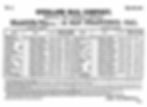
The scheduled trip from east to west was supposed to be completed in 25 days. Passengers shelled out a lot of money for the trip —a full length journey would have cost $200, or over $4,000 according to today's inflation rate. Horses and drivers were exchanged along the route. The schedule was grueling, and it was mostly mind-numbing. Depending on the terrain, the horses (sometimes, mules had to suffice) pulled at about six miles per hour, and there was nothing to do for vast stretches of time. Excitement occurred when the coach got stuck in the mud and the passengers had to free it, or when Comanches or Apaches were spotted along the route. Getting into a town or fort, regardless how small or sparse, was always a welcome relief. Crossing the rivers proved to be the scariest of all activities, and the reason why the stagecoach crossed the larger rivers on ferry boats if it could find one. Most passengers only completed portions of the trip; only one wrote about a complete transcontinental journey. Colorfully named Waterman Lily Ormsby, a prominent engraver, journaled his tour for his newspaper, the New York Herald. He actually shared a portion of the journey with John Butterfield himself as well as with Butterfield's son, Junior, who was the line's first stagecoach driver. His description of the trek at Pecos, Texas best explains the Butterfield experience, "thumping and bumping at such a rate which threatened not to leave a whole bone in my body."
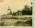
Unfortunately, the Butterfield Overland Stagecoach and Mail Company only lasted from 1857 to 1861. During this brief time, however, the Butterfield became legendary. Towns clamored to welcome the Butterfield. Sherman, Texas for example, paid the stage's passage on Colbert's Ferry across the Red River to ensure that rival Preston, Texas would not be chosen as the point of entry for Texas. While the towns welcomed the potential for commerce, the route actually varied depending on weather, safety reports, and river crossings, especially south of the Red River, whose waters were often described as "shifty." Therefore, the stage route changed its course, and multiple towns could lay occasional claims as stage stops.
The Butterfield counted nine divisions in its 2,795 mile journey. Oddly, the company counted the divisions from San Francisco westward instead of the St. Louis origination point. It traversed the Red River between Divisions 6 (Fort Chadborne to Colbert's Ferry) and 7 (Colbert's Ferry to Fort Smith).
Indian Territory Route:
*Walker's Station at Skullyville aka Choctaw Agency, LeFlore County. Named after the Choctaw governor Tandy Walker.
*Edward's Station near Hughes, LeFlore County. Also called Trahern's Station.
*Holloway's Station near Red Oak, Latimer County. Norris Road follows the exact stage route.
Riddle's Station near Lutie, Latimer County.
*Pusley's Station near Higgins, Latimer County.
*Blackburn's Station at Elm Creek near Pittsburg, Pittsburg County.
*Waddell's Station on Wesley Road at McGee Creek in Atoka County.
*Geary's Station near Atoka, Atoka County. Lucy Geary and her husband operated a toll gate at this station. It's now under Lake Atoka.
*Boggy Depot in Atoka County. The stage coach route is still visible here.
*Nail's Station at the Blue River crossing near Caddo in Bryan County. It's located on Nail's Crossing Road.
*Fisher's Station near Durant in Bryan County.
*Depressions are still visible in the soil at Colbert's Ferry inside the Chickasaw Nation at the Red River in Bryan County. Benjamin Colbert had a hotel here and later operated a toll bridge here, too. The crossing is no longer accessible.
Texas Route:
*Sherman: the county seat of Grayson welcomed the Butterfield with great fanfare. Shermanites even paid for new bridges to be constructed, and the station was one of the best outfitted for the journey. The station was located at the southeastern corner of the square (Glen Sample Ely).
*The Butterfield traveled west on today's TX 56, aka the California Road aka Marcy's Road.
*Diamond's Station: The station outfitted the coach with mules. It sat just to the west of today's Whitesboro, Grayson County, on TX 56.
*Gainesville: The station was at the northwest corner of the square (A.C. Greene) or at the corner of Rusk & California Streets (Glen Sample Ely).
*Davidson's Station on Williams Creek just northeast of Rosston in Cooke County.
*Connelly's Station sat just barely southeast of Sunset and northeast of Alvord near Big Sandy Creek in Montague County.
*Earhart's Station west of Chico, Wise County
*Alternate routes (during turns of weather, troubles with natives, sectional violence. Used mostly in 1861) Denton, Denton County Decatur, Wise County Bridgeport, Wise County
*Jacksboro Station in Jack County at Lost Creek
*Murphy's Station in Young County
*Fort Belknap in Young County was a major stop for the Butterfield.
The period of the Butterfield Overland Stagecoach and Mail route coincided with the Comanche and Brazos Indian Reservations, which were all within a short distance of Fort Belknap. This was mean country, where whites, like John R. Baylor, saw Indians - regardless if they were peaceful or sought war - as despised "savages." After a series of battles in 1858-1859, the state of Texas discontinued the reservations and forced all native Americans living in Texas to relocate to Indian Territory.
*The Louisiana Purchase of 1803 was one of the young country's first constitutional crises, as the constitution had made no provision for which branch of government could negotiate land acquisitions. At the time, Jefferson only had authority from Congress to purchase access to New Orleans and the Mississippi River in order to re-establish the Treaty of San Lorenzo of 1795 (aka Pickney's Treaty or, The Treaty of Madrid). Rights to the Mississippi had only been negotiated with Spain, but this treaty was not inherited when France took over Louisiana again in 1800.