top of page

Search


A Short but Educational Map Tour of the Texas Republic in the 1840s
Maps are great snapshots of contemporary viewpoints that depict past, present, and potential futures, and this is definitely true for maps that depict the Republic of Texas.
Robin Cole-Jett
Dec 27, 2025


The Pawnees, Panis, and the Village at the Red River
Americans identified and described a Panis village at the Red River that was not necessarily Pawnee.
Robin Cole-Jett
Nov 2, 2025


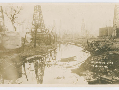
Burkburnett's Oil Pool on Lidar
Enjoying the history of Burkburnett's "Oil Pool" using Lidar!
Robin Cole-Jett
Aug 4, 2025


Seven Years War Map
This map is a detailed representation of the geopolitical situation at the beginning of the Seven Years War (1756 to 1763), a conflict also called the "French Indian War" in the United States.
Robin Cole-Jett
Jul 2, 2025


Things that weren't: Cameron's Grant and a Boundary Line at the Red River
A map from 1835 shows Cameron's Grant and a proposed boundary line, both at the Red River, and both unsuccessful.
Robin Cole-Jett
May 31, 2025


Williams Settlement at the Red River in old Miller County, Arkansas Territory
In maps of the United States/Texas/North America between 1820 and 1825, I noticed a place along the Red River in former Miller County, Arkansas Territory called "Williams Settlement." I began a search that took me into the aftermath of a major earthquake.
Robin Cole-Jett
Apr 13, 2025


The Power of Maps
Color your own power maps from 1601 and 1478!
Robin Cole-Jett
Dec 21, 2024


A Belgian Map from 1825 of the Red River, with Questions
This Belgian Map from 1825 of the Red River of the South leaves more questions than answers.
Robin Cole-Jett
Nov 23, 2024


No Man's Land, AKA the Disputed Territory
Until the 1830s, the Disputed Territory along the Red River, where Arkansas, Oklahoma, Texas and Louisiana meet, was a "no man's land."
Robin Cole-Jett
Nov 3, 2024


Thousands of Mounds, or: Red River Acne
What are these "earth pimples" (acne!) as some researchers have described the circular mounds that appear in all over the Red River Valley?
Robin Cole-Jett
Oct 12, 2024


The Red River Expedition of Custis Freeman & Sparks, aka Corps of Discovery, 1806
For Thomas Jefferson, the most important Corps of Discovery in the Louisiana Purchase was the expedition up the Red River of 1806.
Robin Cole-Jett
Sep 27, 2024


Depictions of the Western Interior Seaway
he Western Interior Seaway of the Mesozoic Era is the reason that the Red River Valley of the South is extremely rich in fossils.
Robin Cole-Jett
Aug 18, 2024


Map, mis-dated
Two maps of the Missouri Territory were either made with a time machine, or one of them is a wee bit older.
Robin Cole-Jett
Aug 6, 2024


A 1656 Map of Naguatex and the Gentleman of Elvas
A 1656 map shows villages like Naguatex, which were described in the 1557 book, Gentleman of Elvas, about the de Soto expedition.
Robin Cole-Jett
Jul 22, 2024


The Ozark Trail, aka the original Route 66
The northwestern portions of the Ozark Trail were subsumed by the federal highway project designated as US 66, aka the original Route 66.
Robin Cole-Jett
Jun 27, 2024


Coates' Bluff, the Original Shreveport
Coates' Bluff was Shreveport's original settlement, the site of a trading post within a Caddoan village.
Robin Cole-Jett
Jun 17, 2024


First Map of the Mississippi
According to Jacques Marquette in 1673, this is the "First Map of the Mississippi River."
Robin Cole-Jett
Jun 12, 2024


More Warren's Trading Post Maps
I found two other maps of Texas, both from the period after Texas statehood (1845), that shows Warren's trading posts.
Robin Cole-Jett
Jun 10, 2024


Warren's Trading House at Salt Creek?
Pressler's 1867 shows Warren's Trading House sandwiched between Panther and Salt Creek (TX), and near Red Creek (OK), but not on Mud Creek.
Robin Cole-Jett
Jun 5, 2024


A Map about an unrealized Future
A map about an unrealized future, drawn to indicate where the Texas & Pacific Railroad would pass once it was built west of Shreveport.
Robin Cole-Jett
Jun 2, 2024
bottom of page


