top of page

Search


Province Texas Map by Stephen F. Austin
Stephen F. Austin traced a Mexican map of the Province of Texas from 1818 and painted it with water colors.
Robin Cole-Jett
Sep 16, 2023


Province of Texas Map, 1818
This Province of Texas map by Mexico was drawn and colored in 1818.
Robin Cole-Jett
Sep 16, 2023


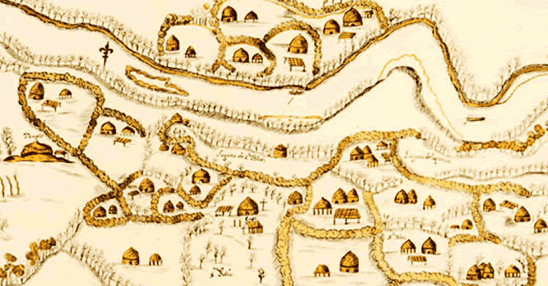
The Yattassee Village along the Red River
A 1721 map places the Yattassee village (spelled Yatachez) on the eastern side of the Red River.
Robin Cole-Jett
Sep 16, 2023


La Harpe and the Nassonite Trading Post
De la Harpe and his men built a wooden trading post at the "abandoned village of the Nassonite chief."
Robin Cole-Jett
Sep 16, 2023


Fort Claiborne, Unwanted
The conflict between the American new-comers and the "old inhabitants" could be seen with the establishment of Fort Claiborne.
Robin Cole-Jett
Sep 16, 2023


Fort Jesup on the Spanish Road in No Man's Land
Fort Jesup, erected in 1822 along the Camino de Real (Spanish Road) replaced Fort Claiborne of 1804.
Robin Cole-Jett
Sep 16, 2023


Theft of the Red River Medicine Stone, a giant Meteorite
The Theft of the Red River Medicine Stone, a giant meteorite, may have deeply affected relations between nations in the Red River Valley.
Robin Cole-Jett
Sep 16, 2023


Anglo Americans in Texas before Austin: Illegal Immigrants on Wavell's Grant and in Miller County
Wavell's Grant was the second empressario granted by Mexcio for Texas, but there were already illegal squatters.
Robin Cole-Jett
Sep 10, 2023
The Original Homeland of the Caddos
The original homelands of the Caddos consist of the Red River Valley from southeastern Oklahoma to Natchitoches, Louisiana.
Robin Cole-Jett
Sep 2, 2023


Natchitoches, le French and Creole City
The French and Creole City of Natchitoches is the oldest colonial city in the Louisiana Purchase.
Robin Cole-Jett
Sep 1, 2023


Fort Los Adaes in Robeline, Louisiana
Fort Los Adaes near Robeline, Louisiana was once the capital of Spanish Texas.
Robin Cole-Jett
Sep 1, 2023


Gold at San Calixto near the Wichita Mountains, aka the Sierra Jumanos, of Oklahoma
San Calixto in the Wichita Mountains - the Sierra Jumanos - was probably the base for gold prospecting after it failed as a mission in 1629.
Robin Cole-Jett
Aug 27, 2023


Fort Sauvage, the Natchez Village after the Fort Rosalie Massacre
The Natchez settlement that was destroyed by French troops and Choctaw, Houma, and Tunica allies in the early 1730s.
Robin Cole-Jett
Jun 21, 2023


De Mézières writing Smack about Natchitoches after Taovaya
After his 1772 visit to Taovaya at the Red River, Athanase De Mézières preferred the villages over Natchitoches.
Robin Cole-Jett
Jan 31, 2023


The Chicken War
In 1936, the Chicken War of 1719 was inadvertently commemorated.
Robin Cole-Jett
Dec 1, 2022


Fur Trade in the Red River Valley
A description of the fur trade in Louisiana during the French colonial era.
Wilhelmina Heloise
Aug 1, 2022


Pedro Vial's map of his Great Spanish Road, Part II
Pedro Vial's map of the "Great Spanish Road" began in Natchitoches and passed by homes and ranches of traders/planters
Robin Cole-Jett
Jul 6, 2021


The Great Spanish Road to the Red River, Part 1
One of the least studied but major trade arteries emanating from the Red River was the so-called "Great Spanish Road."
Robin Cole-Jett
Jul 6, 2021


Humble historic home
Sometime in the 1990s, the federal program called Historic Buildings Survey (HABS) documented the Coincoin- Prudhomme home along the Cane...
Robin Cole-Jett
Jun 29, 2021


A nice long stroll through Chichi
One settlement along this path that interests me is at the western end of the road on this map - Chichi.
Robin Cole-Jett
Jun 29, 2021

bottom of page