
The Wichitas, Natives of the Cross Timbers
- Robin Cole-Jett
- Sep 3, 2023
- 5 min read
Today, the Wichita Nation resides in central Oklahoma, an area that was also their historical homeland. In their own language, they call themselves "the raccoon-eyed people" or Kitikiti'sh, referring to the tattoos on their faces. European accounts identified them as the Ousitas or the Quiverans (in the false belief that a Wichita village would be the mythical, golden city of Quivera).
Home in the Transition Zone
The Wichitas were the native people of the Cross Timbers, a unique landscape consisting of wooded areas of post oaks, elms, hickories in the high elevations and bois d'arcs, hackberries, and cottonwoods in the lower elevations, punctuated by wide, open prairies that stretched from Kansas into Texas. The Cross Timbers is a transition zone, where dense forests of pine, cedar, and cypress in the east give way to the plains of the west. The Wichita culture mirrored this transition well. They were a semi-nomadic people, who hunted bison with the Comanches in the winter months but set up permanent villages in the Spring and Summer to plant and harvest crops like the Caddos, their cousins. They spoke a Caddoan language but their religious practices influenced the Comanches, with whom they also traded and lived in relative peace. Their life ways reflected their location between today's Kansas and Texas, sandwiched among the agricultural kingdoms of the east and the Plains tribes of the west.
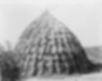
Like the Caddos, the Wichitas were once centralized through a network of large cities, where their leaders and holy people resided. These cities were built around earthen mound pyramids which may have acted as calendars as well as burial chambers for leaders. One of their largest cities has been recently discovered under a golf course near Wichita, Kansas. Just before European contact, their power de-centralized and instead, the Wichitas dispersed. Small villages of large, multi-family clans became the tribal centers. Their houses looked like Caddo homes: thatched grasses in a conical shape, with a fire pit in the center and with thatched arbors on the periphery. The Kaichais, Taovayans, Tehuacanas, Wacos, Wichitas, and Tawakonis made up this loose confederation. Unlike the Caddos, they did not bury their dead in mounds inside their villages, but instead practiced outdoor burials that proffered corpses to the elements. But, like the Caddos, they were matrilineal. Women and men both shared in tasks to build and maintain their villages, and both shared in religious rituals that centered on various dances.
On the move
Originally concentrated along the Arkansas River, the Wichitas moved southward to the Red River by the early 18th century due to warfare with the Osages. Here, they recreated their early settlements along the river with large villages that acted as trading posts for the Caddos, Comanches, French, and Anglo Americans. One of the largest of these villages was peopled by the Taovyans and spanned the Red River between today's Jefferson County, Oklahoma and Montague County, Texas. The Spanish tended to avoid the Wichita villages; while Coronado visited them in the 16th century, by the 17th and 18th centuries the Spanish government referred to them quite fearfully as "los Nortenos" as attempts at mission building were met with warfare. This apprehension was well justified after the Taovayans and Comanches staged a violent, joint attack on the San Saba Mission (Menard County, Texas) in 1759. The Spanish government sent over 600 troops to avenge the deaths of 19 people at the mission, but the Spanish and native soldiers were quickly repelled at the Taovayan village. The battle area became known to later American settlers as Spanish Fort.
After the Spanish took control of the Louisiana Territory in 1763, their overtures became friendlier. They sent a French envoy, Athanase de Mezieres, to the Red River to extend trade and seek peace. Because he was French, the Wichitas reacted well. While de Mezieres accomplished the mission, he also asserted Spanish dominion over the Red River, and named the Taovayan villages San Teodoro and San Bernardo.
Artifact Theft
The Spanish contact inadvertently brought another form of warfare - smallpox. The Wichitas began to suffer the effects of the sustained contact with foreigners, and this was exacerbated by the theft of their Medicine Stone. Near the Taovayan villages lay a large meteorite, which Henry Glass, an American trader, misidentified as platinum. He and a few other men stole the stone in 1806 in an expedition funded by John Sibley, the Indian agent out of Natchitoches. Both the Wichitas and the Comanches revered this stone as medicine. In their belief, medicine was an object that could restore health, vanquish enemies, cast spells, and more. The medicine must be paid for, mostly by an offering/sacrifice, and often was delivered from the object to the requesting person via a medicine man or medicine woman. The medicine stone was so powerful that chunks were taken from it by talisman seekers. The theft of this massive, 1600 lbs meteorite must have devastated the tribe immensely. By 1810, the Wichitas entered a self-described "dark time." They abandoned their villages and consolidated their clans. American descriptions of the encounters with the Wichitas often characterized them as "degraded," meaning that many had taken to drinking and begging.
Brutality towards the Wichitas
The early American period was brutal for the Wichitas. While the Taovayans re-established a village at the base of the Wichita Mountains in Indian Territory near their allies and maintained a number of their traditional ways, the Wacos and Tawakonis who lived south of the Red River in Texas did not fare well. Simply put, Anglo Texans hated Indians - there's no other word that could aptly convey the meanness perpetrated by white men on the frontier against the Wichitas and the Caddos. To Anglos, there was no difference between a Comanche, who had declared a de-facto war against white settlements, and any other tribe.
President Sam Houston extended an olive branch in 1844 at the Treaty of Bird's Fort and at the Treaty of Preston (under Holland Coffee, Indian Agent), which convinced the tribes of the Wichitas and Caddos to remove west of the Trinity River. After Texas became a U.S. state, the federal government, under Randolph B. Marcy's direction, established the Brazos Indian Reservation in Young County to protect the Caddos and Wichitas from Anglo, Comanche, and possible Osage raids. The reservation tribes started farms and accompanied soldiers on scouting expeditions. However, Anglo hostility and paranoia continued; additionally, the Anglo men believed that the military was more interested in protecting the tribes than securing the frontier. In 1859, John Baylor led an ambush against the reservation which killed few on both sides, but was enough for the federal government to disband the reservation. Robert S. Neighbors, acting as Indian agent, led the men and women to a new reservation around newly-built Fort Cobb in Indian Territory. They settled along the Washita River with the Taovayans and the Caddos. On his return to Fort Belknap near the now defunct reservation, a man named Edward Cornett assassinated Neighbors.
The people that comprised the great Wichita tribe were relatively peaceful and cooperative. But repeatedly throughout their history, they were hounded out of their homelands by both hostile natives and Anglos. They still live in their traditional homelands and have organized as a nation, but their territory has been greatly reduced. Even their language has expired - the last known Wichita speaker died in 2016. The Wichitas are a people whose culture is fast becoming a relic.


